Vřesovice archaeological and geophysical Surveys in the Olomouc Region (Moravia /CZ)
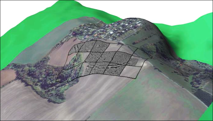
Since 2014, in accordance with the Office for Archaeological Heritage Management Brno and the Department of History of the Palacký University Olomouc, the Institute of Art History and Archaeologies of Europe (Prehistoric Archaeologie) undertakes diverse geomagnetic prospections within the Olomouc Region and concret archaeological investigations in the area of an early Bronze Age enclosure.
Beside the training in recent methods of prospection, surveying and archaeological fieldwork for students, research questions on meaning of an enclosure of the Únětice-Culture within the regional early Bronze Age community and on the function within a transregional network are at the forefront of the archaeological research.
The geomagnetic prospections

map of prospected sites
Since 2014 during fieldwork training for students we prospect sites with archaeological capabilities.
Most of the sites are situated within the Olomouc Region, especially in the Prostějov District, or in close proximity.
In respect to the expected objects we have concentrated to prehistoric enclosures and cemeteries.
Seloutky, okr. Prostějov - geomagnetic results
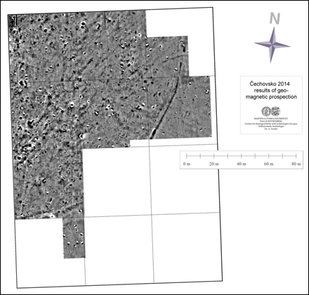
To the north-east of the village Seloutky, okr. Prostějov, we could detect during springtime 2014 in two adjacent areas remains of an early neolithic settlement and partly a ditch, which could be seen as an enclosure.
But by means of the geomagnetic results the temporal relation to the settlement - recognizable by the linear anomalies, as the former pits alongside the houses - is not to clear.
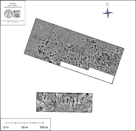
location of the sector fortification at Ohrozim
At Ohrozim we could investigate during summer 2014 an area of 2,2 ha north of a spur above the Čubernice stream, a site already known by surveys and excavations (Šmíd / Příchystal 2015). The geomagnetic results show a double ditch system as a sector fortification, running as an arch from east to west and locking the spur to the north.
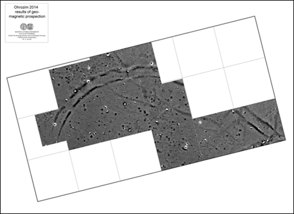
Ohrozim, okr. Prostějov - geomagnetic results
The fortification system consisting of two ditches, interrupted by at least two gatelike entrances in the North and Northwest, can be assigned to the Eneolithic by a lot of surface finds (Šmíd et al. 2010). The central entrance is supplemented and subdivided by a small transversal ditch, an architectural feature, which is also known from other eneolithic fortifications in Moravia, e.g. Úsov, okr. Šumperk (Daňhel 2014 ) or Čechovice, okr. Prostějov (see below).
Only in small areas an inner palisade is preserved, e.g. at the northwestern entrance, also with a gatelike break. Within the enclosed area a lot of bigger pits are visible, continuing to the South. Further pitlike anomalies outside the fortification are situated only in the Northwest. Apart from only a small number of pits or postholes, the area between the two ditches seems to be free of any anthropogenic anomalies.
Čechovice, okr. Prostějov - geomagnetic results
During the same campaign a further eneolithic hillfort could be prospected at Čechovice u Prostějova, okr. Prostějov. Through the geomagnetic prospection within an area of 1,6 ha the course of the fortification system, proven already by excavation (Šmíd 2008), could be completed.
In contrast to the excavation results, the fortification system could be documented only as a single ditch with inner palisade. Solely in the southern part the fortification seems to consist of a multiple / double ditch. Comparable to the situation at Ohrozim settlemet objects are limited to the enclosed area. The entrance in the Northeast as well is crossed by a transversal ditch, but here significantly longer and slightly curved.
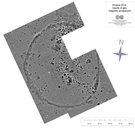
Hnojice, okr. Olomouc - geomagnetic results
Near Hnojice, okr. Olomouc, on a floor area of 3 ha a rondeloid with 175 x 125 m in diameter - already known from airborne prospection - could be documented more detailed also in 2014. As the results show, the rondeloid consists of a single elliptic ditch with an approx. 10 m wide entrance in the South-East, two more or less concentric inner palisades as well and is associated with a bigger concentration of pits, running from the North to South-East.
Because of the fact, that pits superimpose the ditch and the palisades as well, it is difficult to determine which objects could be contemporaneous with the enclosure.

remains of a building ouside the enclosure
While the enclosed area dosen't show any clear domestic structures, approx. 8 m in front of the northeastern part of the ditch a rectangular structure is situated. The West-Northwest/East-Southeast oriented and 22 m long / 7 m wide building has continous wall trenches, intermitted by a 1,8 m wide central entrance in the western narrow side.
Initially assumed as a late neolithic "Rondel", we have addressed the structure after the prospection rather as Bronze Age. Not only because of the architectural features but the dimesions as well. Immediatly after the prospection this suggestion was confirmed and made more concrete on the basis of ceramic finds and radiocarbon data from the refilling of the ditch during an excavation. The structure now can be dated to the late Middle Bronze Age / early Late Bronze Age (BZ C2-D) (Daňhel 2015 ).

Čertoryje - geomagnetic results
In summer 2015 a quit similar structure - both in shape and in orientation - has been documented near Čertoryje, okr. Olomouc. But the North-South oriented elliptical rondeloid is with 74 x 60 m in diameter as half as big as Hnojice. Furthermore the single ditch is interrupted by four 2.6 - 3.0 m wide entrances, not exactly but nearly oriented to the cardinal points (North, East-Southeast, South-Southeast and West-Northwest).
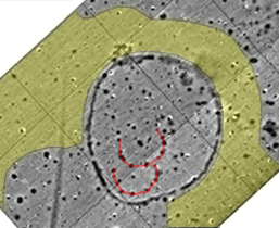
semicircular structures & zones without pits
Beside the ditch the area (2,3 ha) shows a lot of bigger pits. Although some pits superimpose the ditch, one concentration within the enclosed area is recognizable, espacially in the southwestern half. Here - randomly or intantionally - two groups of 6 - 10 pits with a distance of 7 - 8 m from each other form two semicircles around central pits. Furthermor an absence of bigger pits - aside from a few pits - in the northwestern part of the prospected area and a 20 - 30 m wide zone almost free of pits North and East around the rondeloid is noteworthy.
Expect some indications of a late Bronze Age cemetery nearby and the similarities to Hnojice there are no hints for dating.
Hallstatt tumuli near Prostějov
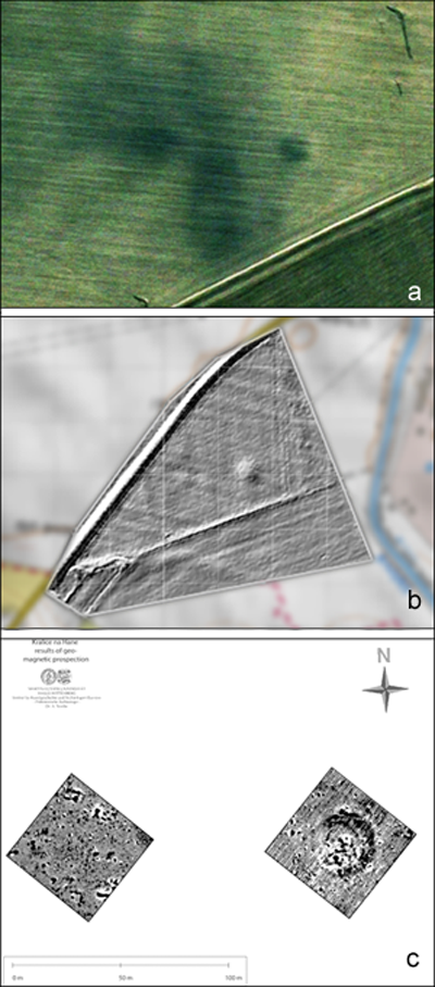
2015 we were asked to check the possible existence of early Iron Age tumuli on a site near Prostějov known from surveys. To get first evidence for the presence and a more precise localization some satellite images (© Digital Globe) were examined during the perperation stage. Based on this images two rounded structures, 20 - 30 m in diameter were detectable beside a linear geological structure (a).
By aditionally use of high resolution DSMs (© Geoportál ČÚZK, fourfold exaggeration) the presence of one tumulus with a height of still approx. 0.6 m (b, right) and a second badly destroyed tumulus (b, left) could be verified.
Add-on geomagnetic surveys have confirmed the structures and their state of preservation. While for the better preserved tumulus (c, right) a circular enclosure surrounding the potential solidified mound - with a great number of (recent) metal or burned objects - was detectable, no traces of the second tumulus have remained. Only the circular distribution of bigger pitlike anomalies around a 30 m wide place in the center of the prospection square can be seen as an indicator of a former mound probably (c, left).
cemetrey near Kostelec na Hane
2016 we were able to visit a site, which had provided some interessting finds from the Iron Age. Already due to these finds a burial place was suggested.
Because of the plant groth and the distance to our camp, the geomagnetic measuring could carried out only for a very short time. That's why only a 100 x 100 m area arround GPS-date of the most interessting surface finds was prospected.
The results show a loose scattering of some bigger round or oval / rounded rectangular pits (yellow). Towards the edges of the prospected area pits are present only in a small number - and with smaller size - or totaly abscent. But at the northeastern corner a further interesting object could be discovered (red). This object consisting of a more or less quadratic 8 x8 m wide anomaly could represent remains of a so called "Grabgarten", an enclosure of a late Iron Age burial place.

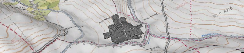
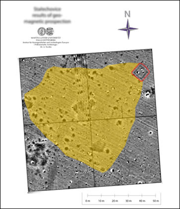
Vresovice results

vresovice terrain
Excavations at Vřesovice
<in prep.>